Geography of Sweden: Important Geographical Information about Sweden
In this Country Profile
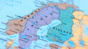
Sweden, located along the Scandinavian Peninsula in Northern Europe has an estimated population in 2011 of 9,453,000. Norway shares border with Sweden in the west while its eastern section is bordered by Finland. The Gulf of Bothnia and the Baltic Sea also share borders with Sweden. The largest city is Stockholm, its capital and Malmo and Goteborg are two other large cities of the country. Its total land area is 450,295 square kilometers or 173,860 square miles. It also has quite a long coastline measuring 3,218 kilometers or nearly 2,000 miles. Many smaller islands compose the country that is Sweden. The country is basically rectangular in shape, long and narrow. It is about 310 kilometers or 500 meters wide and 1,600 kilometers or 995 miles long. Lake Hammarsjon, at -2.4 meter or -7.8 feet below sea level is the lowest point of Sweden, in contrast to Kebnekaise, soaring 2,111 meters of 6,926 feet, which is the highest point in the country.
Sweden is known for its natural environment and has several dense forests, which cover about two-thirds of the whole country. A number of rivers run through Sweden, complemented by about ten thousand lakes. It is also rich in mineral deposits, including sizeable iron deposits and about 15% of the world’s uranium. With the various bodies of water running through it, the country is also rich in hydropower.
The country’s topography is characterized by gently rolling or flat plains although mountains exist on its western section, near its border with Norway. This is the location of the glacier-covered Mount Kebnekaise. Three rivers, Torne, Angerman and Ume flow into the Gulf of Bothnia on the east coast of Sweden. Vänern, the third largest lake in Europe and Western Europe’s largest, lies to the southwest of the country.
Sweden is divided into three regions. The northern part is Norrland. The area has plenty of reindeer, waterfalls, lakes, rivers, snow and thick forests. Norrland, which covers almost half of the country, is noted for the northern lights and the midnight sun, two exciting natural phenomena. Gotäland is the name given to the southern part of Sweden, where the rich soil is very suitable for agriculture. Svealand is the central region of the country. This region is the location of the Vänern Lake, other minor lakes, hills, forests and plains, providing the area with rich and fertile farming lands.
Climate
The Koeppen-Geiger classifies the climate in Sweden into three different zones. In the south the climate is warm temperate and humid, with the warmest month having an average temperature of 22 °C or nearly 72 °F, while four months of the year have an average of over 10 °C or 50 °F. The mountainous region has an ice climate, where the average temperature during the warmest times of the year is below 10 °C or just 50 °F. The northern and middle areas of Sweden have a snow climate with some humidity, where for about four months of the year experience temperatures that are above 10 °C (50 °F) on the average.
Generally the climate in Sweden is classified as subarctic in some parts and temperate in others. However it is milder compared to other countries that are located farther north. This is because Sweden’s climate is tempered by the warm Gulf Stream that comes from the western coast of Norway, further enhanced by the Gulf of Bothnia and the thousands of lakes found in the country. Its northern location however is also beneficial particularly during summer as the humidity levels are not very high and the temperature remains quite pleasant. While the summers may be cool up north, the winters in this region usually have lots of snow and could be very cold. In the southern part of Sweden, the summers are warmer although it is also the time for rain to pour. Milder winters are experienced in the south.
Northern Sweden is also in the Arctic Circle and the region experiences long periods of chilly winter. During winter up north, the region remains dark for about two months and receives more daylight hours continuously for two months in the summer. Hence, this region is called the Land of the Midnight Sun. A natural phenomenon, the multicolored, superb and intriguing displays of the Aurora Borealis, also called Northern Lights, is a fantastic winter night sky spectacle.
Stockholm, the nation’s capital enjoys a milder climate compared to the rest of the country because it is in the southern part of Sweden and is along the coast. The average low in January in the capital city is -5 °C or about 23 °F while the high temperature in July is just 22 °C or just 71.4 °F. Normally the average temperature in July ranges from 13 °C to 17 °C, which is about 55.4 °F to 62.3 °F. The coldest month is February, when temperatures go down from -22 °C or -7.6 °F to -3 °C or 26.6 °F. It is a regular sight to see the grounds in the southern section of Sweden covered in snow from December until April, while snowfall starts around October in the northern section of the country.
References
http://geography.about.com/od/swedenmaps/a/geography-of-sweden.htm
http://www.earthyfamily.com/S-geog.htm
http://www.weatheronline.co.uk/reports/climate/Sweden.htm
http://www.visitsweden.com/sweden/Sweden-Facts/Worth-knowing-about-Sweden/Weather/
http://www.dogsledding-adventures.com/About/Sweden.htm

Sorry, the comment form is closed at this time.